
We have been riding our bikes around some top cycle routes in Derbyshire and the Peak District for many years now. To help you find the right path we have compiled this list containing some of the best bike trails. Furthermore, many of these routes are traffic-free and family-friendly trails that can be enjoyed by all. Over the years we have filmed many of the routes we ride, and all five routes on this list have an associated video.
Here are 5 of the top cycle routes in Derbyshire & the Peak District…
- Highpeak Trail
- Longdendale Trail
- Manifold Track
- Monsal Trail
- Tissington Trail
1. High Peak Trail

The High Peak Trail is around 18 miles, it goes from High Peak Junction to Dowlow, near Buxton. This traffic-free route follows the line of the former Cromford and High Peak Railway.
We usually start at Parsley Hay and head SE along the trail. As you can see from the profile above, there are several steep descents if you go all the way to High Peak Junction.
There are four inclines/declines on the trail towards the Eastern end of the route. Therefore making this end of the trail extremely difficult for a cyclist who does not like, or is unused to hill climbing. The slopes originally carried the railway over 1000 feet (305 m) in just 5 miles (8km). The four inclines are known as Cromford, Sheep Pasture, Middleton and Hopton which range from a 7 to a 12% incline.
If you are heading out from Parsley Hay and you or members of your party do not want to climb too many mountains on your cycle ride then consider stopping at either Middleton Top or Black Rocks. Have some lunch then ride back to Parsley Hay.
Overall this traffic-free offroad-trail is a great ride, if you enjoy slogging up the inclines, you will love it all the more. The scenery is fantastic, facilities at the various stops are good, especially the cafe at Black Rocks.
Places of Interest on the High Peak Trail
Parsley Hay A great place to start the ride, they have picnic areas, public toilets and a snack shop in addition to their bike hire and parking facilities.
Midleton Top: There are several facilities that you can take advantage of at this location. There is a car park and a visitor center, where cycles may be hired. You can also find the Middleton Top Engine House, which houses a steam engine that was used to haul trains up the 600 meter Midleton Incline.
Black Rocks: There are lots of facilities available here for a visitor to the Tissington Trail. There is a wildlife area, cafe, toilets, picnic area, footpaths and public access woodland as well as ample parking.
High Peak Junction: On the Cromford Canal, it is mile South of Cromford village. There is a visitor center, cafe and some oldest surviving railway workshops for you to explore. In the past High Peak Junction was the hub of transportation activity and is now a true haven of heritage.
2. Longdendale Trail

I found it incredibly easy to compile our “5 Top Cycle Routes in Derbyshire & The Peak District” list, because there are so many good cycle routes in the area. The Longdendale Trail is one of the best if you are looking for a short cycle route.
The Longdendale Trail is a short 6.5 miles each way but it is always a great route that we enjoy riding. The trail follows part of the route of the Woodhead Railway Line. The railway line used to run between Manchester & Sheffield however, it was closed in 1981.
The trail, which opened in May 1992, forms part of the longer Transpennine Trail (TPT). It is also known as the National Cycle Network Route 62. The TPT is a long-distance coast-to-coast route that stretches from Southport on the West Coast to Hornsea on the East Coast.
We have ridden the Longdendale Trail many times and the scenery encountered on this ride is breathtaking. The route is never extremely busy, so it is a great trail if you want to spend some time on one of Derbyshire’s less busy cycle routes.
Places of Interest on the Longdendale Trail
Hadfield; is a small town located on the Western end of the trail. It is a great place to stop, eat and drink. Although small it has many facilities available to cyclists or walkers using the trail.
Woodhead Tunnels: Located at the Eastern end of the route is a collection of three parallel tunnels stretching for 3 miles under the Pennine hills.
3. Manifold Track

The Manifold Track is a great walking or cycling route in Staffordshire. The trail follows the route of the old Leek and Manifold Light Railway. It runs for around 8 miles from Hulme End down to Waterhouses.
It has more road sections than any of the other bike routes on this list, which can have occasional traffic on, therefore I can not consider this a traffic-free route. Although it is close.
The terrain you will ride or walk through is varied, it could be woodland, road, farmland or open meadows. If you like various parts of the countryside, then you will love some parts of this cycle route.
Places of Interest on the Manifold Track
Hulme End; the station is now a visitor center which has been the start location of all our trips down the Manifold Valley. There is parking available, cycle hire, public toilets, a visitor center and a cafe.
Thors Cave: is a natural cavern that is located around 260ft above the track in the Manifold Valley. It is a great landmark as well as a popular tourist attraction. If you have the energy you can follow a stepped path that goes up from the cycle route to the entrance to have a look inside.
Waterhouses: When you reach the Southernmost point of the Track you will be in Waterhouses. Crossing the road and following the track up a short steep ramp will bring you out to a cafe/snack shop where you can hire bikes. Alternatively going and exploring the village it’self is also a great option.
4. Monsal Trail

We always enjoy cycling on the Monsal Trail. It is a great route that can be enjoyed by anyone, regardless of their cycling ability. The Monsal Trail is almost 9 miles long and stretches from Coombs Road, Bakewell to Topley Pike Junction, Wye Dale. In my opinion, this bike route is the best example of off-road traffic-free cycling available in the Peak District, earning its place on our “Top Cycle Routes in Derbyshire” list.
The route follows part of the Manchester, Buxton, Matlock and Midlands Junction railway. The railway was closed in 1968 and the route passed into the hands of the Peak District National Park in 1980.
The route was opened to the public in 1981. Initially, four of the tunnel sections remained closed due to safety concerns. Work was completed in 2011 to make all of the tunnels safe and consequently, the Monsal Trail in all its glory was made accessible to the public.
Places of Interest on the Monsal Trail
Hassop Station; is a great starting location as it has some fantastic facilities, a Cafe, Bike Hire and a Book Shop as well as ample paid parking.
Blackwell Mill Cycle Hire: If you need to hire a bike or two there is also cycle hire available at Blackwell Mill. It’s a great place for a light snack, quick drink or hiring a bike for the day.
The Refreshment Room: Additionally there is another Cafe on the trail that has recently opened at the old Millers Dale Train Station. There is also ample parking with easy access right next to the trail at Millers Dale.
5. Tissington Trail
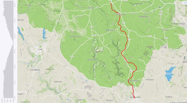
Although there are many places to join the Tissington Trail throughout its length, our usual location to meet is the visitor center at Parsley Hay. Here you will find paid parking, a bike shop with hire facilities as well as a small hatch serving snacks and refreshments.
The Tissington and High Peak Trails merge close to Parsley Hay, so it is, in fact, an ideal starting location for both routes. From Parsley Hay, the Tissington Trail heads south through fantastic Derbyshire countryside and finishes in Ashbourne. The Highpeak Trail goes East to Cromford.
This trail is a favorite ride of ours and is around 13 miles from Parsley Hay to Ashbourne. We often cycle up to the carpark at Hurdlow at the start of the ride, adding on a few more miles. This should take a casual cyclist 3-4 hours when including a relaxing stop for lunch.
Although the Tissington Trail is popular with both walkers and cyclists alike, it is never quite as busy as the Monsal trail, which is located close by. Tissington Trail is one of our favorite routes, therefore, it is deserving of its place on the top cycle routes in Derbyshire & the Peak District list.
Places of Interest on the Tissington Trail
On the route, there are numerous places to stop and have a picnic or take a break. Hurdlow, Alsop and Thorpe have Picnic and areas.
Hartington Station has toilets, a picnic area, a car park and the signal box is sometimes open for snacks.
Tissington Railway Station; has public toilets, a snack shop, picnic as well as seating areas. This is also the location where we sometimes leave the Tissington Trail to head out towards Carsington Water.
Mapleton Lane and Parsley Hay both have picnic areas, a snack shop & bike hire facilities, therefore, they tick a lot of boxes on the facility list.
The Royal Oak at Hurdlow is a nice pub that has a great menu. Additionally, they have a camping area that is good if you are looking for somewhere to pitch a tent for the weekend.
I hope that you enjoyed our 5 of the Top Cycle Routes in Derbyshire & The Peak District article, If you want to explore some more of the top routes that we cycle, then please check out our YouTube channel Here
Do you want to see more of our written articles? Click here